
City of Encinitas
Home MenuWelcome to the City of Encinitas!
POPULAR SEARCHES
Geographic Information Systems
GIS Mission Statement
To educate and empower City of Encinitas residents, staff, visitors, and regional partners by providing efficient, accessible, and high-quality spatial data services and solutions.
GIS Overview
Geographic Information Systems (GIS) is responsible for administering, creating, maintaining, and operating the City’s GIS data, which is integrated throughout the City's GIS-centric business applications. Daily operations include: supporting the City’s enterprise GIS-centric business applications; creating and maintaining GIS map applications for the public; maintaining data in the GIS database; leading data capture/conversion projects; creating customized maps and reports for staff; assisting with mailings for City project notifications; and providing digital data and maps to City contractors, consultants, and the public.
At the City of Encinitas, GIS is used to…
- Find out detailed site information
- Assist the public
- Perform all aspects of Land Records
- Assist with the annual NPDES report
- Manage Clean Water best management practices (BMPs)
- Conduct dry weather monitoring
- Inspect storm water complaints
- Determine inspection prioritization
- Assist fire personnel with response calls
- Inspect fire hydrants
- Assist in emergency operations
- Map fire pre-plans
- Manage coastal bluffs
- Help make decisions in SAC meetings
- Assist with plan check review
- Manage affordable housing
- Manage and maintain City assets
- Comply with regulations
- Help determine budget
- Help determine project costs
- Assist with project and event notification mailings
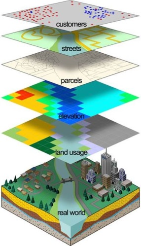 What is GIS?
A GIS allows you to integrate different layers of information, which means you can much more easily see the whole picture. GIS is used to help make many work processes more efficient and effective because approximately 80% of all business data has a location component. Linking location to information applies to many aspects of decision making in business and the community.
By providing staff the ability to query and analyze mapped information, staff are better equipped to provide recommendations on City policy, service improvements, and future community developments. GIS has become increasingly important to the work flow processes of the City by integrating data from all departments in a visual way and by providing interactive and user-friendly mapping and analysis capabilities.
City Maps
The following city maps are available for viewing or download. For better viewing on screen, you can right-click the PDF and select the Marquee Zoom tool (click to zoom in; ctrl-click to zoom out) or the Hand Tool (pan). In addition, if you would like to download and print, please note that these PDFs are meant for plotting on an E-size sheet which equals a 34x44 inch poster size. This print size is necessary due to the fixed text annotation of the map documents.
- Zoning - citywide zoning designations
- Specific Plan Zoning - zoning designations for specific plans
- Land Use Policy - citywide General Plan land use policy designations
- Parcels & Roads - citywide street map with parcels and public and private ROW
- Recreational Trails Master Plan - existing and proposed trails in the city as designated by the Recreational Trails Master Plan
- Hillside Inland Bluff Overlay Zone Map
- Floodplain Overlay Map
- Voting Districts Overview Map
- Voting District 1
- Voting District 2
- Voting District 3
- Voting District 4


